 Ground Penetrating Radar (GPR)Use at Camp Edwards
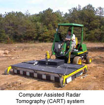
The 3-D ground-penetrating radar (GPR) is used for mapping, identifying, and locating buried metal and non-metal objects and geologic structures. Description of the Technology
Ground Penetrating Radar (GPR) produces images of structures and objects below ground using reflected high frequency radio waves. The signals are sent out from a surface transmitter antenna into the ground. As broadcast signals from the object pass through the GPR, a 2-D image of the data is displayed on a computer that is connected to the GPR unit. All of the data transmitted from the object is collected instantly. Later, advanced data processing and analysis of the GPR data is completed using Computer Aided RADAR Tomography (CART). The analysis produces a 3-D tomographic image of the GPR reflected signals. This image can be used to estimate the depth of the buried object, assess the object's approximate size, and depending upon conditions, yield information regarding the object's shape and/or orientation. | 